Jantar Mantar Observatory in Jaipur

Jantar Mantar Observatory
Picture of Jantar Mantar
Photo by: mckaysavage, Creative Commons

The Jantar Mantar is an observatory located in Jaipur City, state of Rajasthan, India.

The Jantar Mantar was built by Jai Singh II (emperor of the Amber dynasty) in between the years 1727 and 1734. There are a total of five Jantar Mantar observatories of the same style built by the emperor at different places. Among the five constructions, the Jantar Mantar observatory at Jaipur is considered as the biggest of the five. In the year 1948, the Jantar Mantar observatory was stated as the National Monument.

The name “Yantra” actual word Jantar means “an instrument” and “Mantra” means “principle”, the people of Rajasthan pronounce the word “Ya” in place of “Ja”.

The Jantar Mantar was built with marble, several stones and bronze sheets; the placement of these materials is very accurate. The Jantar Mantar observatory is also known as “time machine”. It contains 14 numerical devices which are used in time measurement, approaching eclipses, discovering new planets, present condition of the planets and predicting about the outer space altitudes.

Among the devices inside the Jantar Mantar, the biggest instrument is the “Samrat Jantar”, which is about 90 feet high and faced at 27 degree latitudes to Jaipur city. The Shadow of Samrat Mantar is plotted in such a way that the time can be calculated based on the instrument. The Samrat Yantra (sundial) is also the world’s biggest sundial which calculates the accurate time of Jaipur city every two seconds. In addition there is a small dome on the top of the Samrat Jantar which predicts the seasons and eclipses.

In the present days, the Jantar Mantar observatory is a great tourist spot, the people of this city still use the Jantar Mantar for the prediction of weathers. The Jantar Mantar is also filmed in many national and international films and has become a great spot for shooting films.

Traveling to Jantar Mantar observatory
The Jantar Mantar opens at 9:00am in the morning and closes 4:30pm in the evening.
Jaipur being the capital city of Rajasthan state and also second largest tourist spot in India is well connected with all the parts of the country. In addition there are several bus services from all the parts of Rajasthan state. People traveling there can choose their means of transport according to their interest.


»»  Read More

Jama Masjid in Delhi

Jama Masjid-thumbnail
Gloomy day at the Jama Masjid
Photo by: Saad.Akhtar, Creative Commons

The Jama Masjid is located in Delhi (the capital city of India). Jama Masjid is the biggest mosque in Asia. The construction of the Jama Masjid was ordered by the emperor Shah Jahan in the year 1656, which was also the year the Taj mahal was built (one of the seven wonders in the world). The Jama Masjid courtyard can occupy at least twenty five thousand people at a time. The unique feature of the Jama Masjid is the Quran which is written on Deer’s skin.

About 5,000 workers were involved in the construction of the Jama Masjid, taking about six years. The cost involved in the construction in those times was about 10 million rupees in today’s economy. In addition, several other mosques were built near Ajmer, Agra, Delhi and Lahore.

The mosque has seven domes each having a tower in the middle. In addition, there is a hall where prayers are offered, the length of the hall is about 61 meters, where there are 11 entrances to the prayer hall. The mosque has two huge minarets which are about 41 meters high, and there is 130 steps built with red stone and marble. In addition there are four minor minarets to the back side of the mosque.

There are several different ways to reach the mosque’s courtyard, which includes the north, south, and east directions containing steps which are built of crimson stone. There are 39 steps from the north gate,33 steps from the southern gate and 35 steps from the east gate which is the main entrance to the mosque. In the evening times, the steps of the mosque are converted into stalls, book stalls and eatable places. The western side of the mosque is converted into poultry where birds and meat are sold. In the southern part of the mosque books are sold.

Traveling
The Jama Masjid being located in the heart of the Delhi City. Delhi being the capital city of India is well equipped with all means of transport. People traveling there can choose their way of transport according to their interest.

»»  Read More

Hawa Mahal Palace in Jaipur

hawa-mahal-palace-thumbnail
Hawa Mahal in gorgeous lighting
Photo by: The Wandering Angel, Creative Commons

The Hawa Mahal Palace is located in Jaipur city (capital of the Rajasthan state), India.

Maharaja Sawai Pratap Singh built the Hawa Mahal Palace in the year 1799; Lal Chand Usta designed the palace in the form of Lord Krishna’s Crown. The Hawa Mahal Palace is a part of the Royal Palace including the women’s chambers. The Hawa Mahal palace was built to examine the day-to-day life of the royal women.

The Hawa Mahal Palace (Palace of the Winds) consists of five floors, which is built of pink and crimson sandstone and white lime. The Hawa Mahal palace has 953 windows, which faces towards the street outside the palace. A huge amount of breeze circulates through these windows even in summer, due to this reason the name was kept as Hawa (breeze) Mahal. The palace was painted with ochre-pink, also known as color of generosity.

The Palace contains a double-floored building on all the three sides and another three floors in the eastern division of the palace. There no are no steps to reach the palace, the only way the palace can be reached is through the ramps.

In the present day, the Hawa Mahal has become a famous tourist spot and one of the spectacular sights in Jaipur. From the palace, the entire Jaipur city can be seen. The palace has become a great spot for the shooting of several Indian and international films.

Traveling to the Hawa Mahal:
Jaipur being the capital city of Rajasthan and the second largest tourist spot in India is well connected by all means of transport.

The nearby airport is the Indira Gandhi international Airport.

Frequent train services are available from the major cities in India. The nearby railway station is the Jaipur station.

In addition, the Rajasthan state government provides several bus services.

»»  Read More

Hampi Village

Hampi Thumbnail
View of Hampi
Photo by: Vijjugadu, Creative Commons

Hampi is located in the state of Karnataka, India. Hampi was the capital to the Vijayanagar Dynasty during the medieval period. Hampi village is also a religious place, which has the historic Virupaksha Temple belonging to the 7th century. In addition Hampi has several Hindu Temples belonging to the ancient past. UNESCO listed some of Hampi’s monuments as the world heritage site.

Hampi is recognized as the Ramayana (Sanskrit epic), where Hampi was the empire of King Sugriva (belonging to Vanara dynasty). Hampi has the historical settlements since 1 C.E. Hampi is situated close to the Tungabhadra River bounded by the hills on all three sides.

Hampi is famous for its history and ancient architecture, Hampi displays a large number of Hindu idols statues, which were built on a single large stone. These statues are so big that one can still see it from a half kilometer distance. Most of the historical belongings are in ruins, a large number of structures are destroyed.

Hampi has several historical places, among them is the historical Virupaksha Temple. The Virupaksha temple was built in the 7th century, which is devoted to Lord Shiva. The temple is about 49 meters high. In addition there are Pampa and Bhuvaneshwari (Hindu Goddess) sub temples within the Virupaksha temple building.

In the present day, Hampi is a great tourist spot, which is visited by the people from all parts of India. The languages spoken at Hampi are Telugu and Kannada. Hampi is the greatest producer of Manganese and Iron ore. The Karnataka government organizes a festival every year in November known as “Vijayanagar Festival”, which conveys the traditions and life style of the Vijayanagar kings.

There are several sights seeing place in Hampi which are listed below.

* Akka Tangi Gudda

* Kamalapura Archaeological Museum

* Anegondi

* Tiruvengalanatha Temple

* The Underground temple

* Tungabhadra River

Traveling

Hampi can be reached by using the Bellary airport. Only Air Deccan airways operate its services from Bangalore (the capital city of Karnataka state).

The closest railway station to Hampi is the Hospet railway station which is 13 km away. In addition there are several train services available from Goa, Hyderabad (the capital city of Andhra Pradesh state, India), which costs about 700Rs, which is a reasonable price.

The Karnataka road transport operates frequent bus services from Bangalore, Mysore, Hospet and Gokarna cities.

»»  Read More

Golden Temple of Amritsar

Golden Temple in India
View of the Golden Temple in India
Photo by: appaji, Creative Commons

The Golden Temple in India, which is often called the “Darbar Sahib or Harmandar Sahib” by the Indians, is one of the oldest places of worship for the ‘Sikhs’ and is located in Amritsar, Punjab. It is considered one of the holiest, blessed and sacrosanct places in India. It is a symbol of both beauty and peace. The temple is surrounded by a small man-made lake which has tons and tones of fishes in it. This lake is supposed to have holy water. The temple can be entered from four different sides and thus symbolizes openness, acceptance. This concept is based on the old tents which were open from all four sides, welcoming travelers from all directions.

The Golden Temple has three holy trees. There is also a small Sikh Museum near the Ghanta Ghar in Amritsar which is very rich in information, especially for the first time visitors. The entire top of the temple is made of pure gold and thus adds a lot of pride and beauty to the entire temple.

During the earlier days, this place was a huge lake surrounded by a thin line of forests. It is also said that Buddha journeyed to find out the real meaning of life spent some considerable time in this place. The first guru of the Sikh community called the Guru Nank also used to meditate in this peaceful place and years after he passed away, many of his disciples kept coming back to the site and then it finally became a sacred place. It was during the Fifth Guru, Arjana when the Temple was finally built 1604. It was Guru Arjan who installed the “Guru Granth Sahib” in the temple and appointed the first reader in August 1604. The temples architecture is that of both Hindu and Muslims. On many occasions, it was destroyed by a certain set of community and rebuilt by the Sikhs.


»»  Read More

Girnar Temples in Junagadh

Girmar Temples thumbnail
View of the Girnar Temple from higher grounds
Photo by: Emmanuel Dyan, Creative Commons

Girnar is located in the Junagadh region which is 327km from Ahmedabad (the largest city in Gujarat), in the state of Gujarat, India.

Since the 3rd century, Girnar has been a major religious place. Girnar is also a sacred place for Jains and the Hindus. Girnar Temples is known to be the “anthology of mountains” which contains about five mountains. The tallest among the mountains is 945 meters high. The first mountain contains Shwetamber and Digambar temples (Jain temples), these temples stand as a fine example in terms of architecture which portray the carvings on the temple structures.

There are almost 8,000 steps located from the starting point of the first peak to the very last shrine. Girnar is a sacred place for Jains and Hindus, which attracts a large number of pilgrims. The pilgrims climb all 8,000 steps barefoot as a belief that a person who climbs all the steps barefoot reaches Heaven.

The Neminath temple at Girnar is the major temple, which was built in the 11th century. The temple contains the deity of Lord Neminath, which is made of black granite and the eyes of the deity are made of precious jewels. The temple complex contains open space, courtyards, and several other minor temples. The temple roofs are inscribed with Goddesses in a dancing form. In addition, there is another temple known as Mallinath temple within the Neminath temple which is devoted to Tirthankar (Jain god). The temple was built in 1231 AD by Tejpal and Vastupal.

Besides these temples there are some minor temples namely Meravasi built in the 15th century. Married couples visit this temple to seek blessings. In addition, a mosque is located near the temple where childless women visit to enhance their fertility.

In the present day, Girnar is one of India’s biggest pilgrimage places. A race is conducted every year, the race involves climbing to the top of the 8,000 steps. A large number of people take part in it, and is the major attraction here.

Traveling
The nearby airport to Girnar is the Keshod airport, which is 40km from Girnar.

Traveling by train is the easiest way, train services are frequently available from Ahmedabad City.

From Junagadh daily services are available which is about 5km from Girnar, in addition the Gujarat state provides bus services from all the major parts of the state.

»»  Read More

Gateway of India in South Mumbai


Gateway To India Thumbnail
Gateway to India Archway
Photo by: poida.smith, Creative CommonsThe Gateway of India is located in South Mumbai, in the state of Maharashtra, India.

The Gateway of India is built with yellow basalt (extrusive volcanic rock) and concrete. The architecture of the Gateway is purely Indo-Saracenic (combination of Indian and Islamic architecture) style. The arch of the gateway is about 26 meters; the dome at the center is about 15 meters in diameter and 26 meters from the ground surface. The Indian government spent 21 lakh Rupees for the Gateways construction.

The plan to build the Gateway of India started in the year 1911, and it was built to mark the trip to Mumbai by King George V (emperor of India during the British rule in India) and his wife Queen Mary. The gateway was designed by George Wittet , the construction of the Gateway began in the year 1915. Construction of the Gateway was extremely slow, where only a wall was built over four long years. In the year 1920 the foundations were finished and finally in the year 1924 the total construction was completed. Finally in 1924, December 4th British Viceroy opened the Gateway. The British people used the Gateway to receive their guests who visited Mumbai.

In the present day, the Gateway of India is a crowded area and is the most visited place in Mumbai. People, especially from Mumbai , use this place as a hang out area.

Traveling
Mumbai, the India’s largest city, is well connected with all means of transport from all the parts of the country and all the parts of the world. People traveling there can choose their means of transport according to their interest.

The local traveling in Mumbai is a great experience where different means of transport are available; such as the local trains stopping every 10 minutes from Bandhra, Chatrapathi, Sivaji, and Andheri railway stations. Everyday 7 million people travel in these local trains.

In addition taxis, autos, and bus services are frequently available from all parts of Mumbai.

»»  Read More

Fatehpur Sikri, West of Agra

Fatehpur Sikri
Fatehpur Sikri in India
Photo by: foxypar4, Creative Commons

Fatehpur Sikri is a royal city situated 40 miles west of Agra, Uttar Pradesh, northern part of India. It is listed as one of the world’s heritage site by UNESCO due to its unique features and it is one of the major destinations in India. This city served as the capital of the Mughal Empire during 15th century. This glorious city was planned by Akbar, the great emperor of Mughal dynasty. The name Fateh is originated from Arabic which means “victory” and Sikri means “thanks to god” and the city came into significance when Akbar the Great made it as head quarters and built a majestic fort. But this city was abandoned due to the scarcity of water in the town.

There are number of buildings in Fatehpur Sikri built mostly with red stone. The compound has small palaces which were built for specific purposes.

Naubat Khana: it is the drum house situated near the entrance where important arrivals are announced.
Diwan-i-Am: it is the hall for public audience which is found in most of the Mughal buildings with large open space.
Diwan-i-Khas: it is hall of private audience and it is famous for its decorated pillar consisting of 36 elegantly carved brackets made in Gujarati style.
Raja Birbal’s house: it is the house of Akbar’s favorite minister who is renowned for his intelligence.
Marium-uz-Zamani: this is built around courtyard for complete privacy made in Gujarati style.
Panch Mahal: it is a five storied impressive structure which has 176 carved columns on the ground floor. It is the most fascinating building in Fatehpur Sikri.
Buland Darwaza: it is a huge gateway to Jama Masjid which is a fantastic piece of architecture and it is termed as “gate of magnificence”.
Jama Masjid: it is a mosque where Muslims follow prayers everyday.
Tomb of Salim Chisti: it is the white marble encased tomb of Salim Chisti who was Sufi saint and also the person who was very honored by the great Akbar.

The city of Fatehpur Sikri is only 40 kilometers from Agra which is well connected by air lines connecting all important cities of India. It even has good transport facilities through bus and train as well along with hiring taxis. It is open from sunrise to sunset. The entrance fee varies for the tourist from different countries and for children below is absolutely free.

The architecture of Fatehpur Sikri has its unique character composed with Indo-Muslim style and perhaps one can experience the aura of its magnificent edifices by visiting these kinds of extra ordinary places.


»»  Read More

Ellora Caves in Aurangabad

Ellora Caves
Ellora Caves in Aurangabad, India
Photo by: markhillary, Creative Commons

Ellora Caves, an archeological site situated 19 miles from the city of Aurangabad, Maharashtra, India. It is listed as one of the world heritage site by UNSECO. It is the finest example of rock cave temple in India with 34 caves in total. It is believed that these caves were built by the rulers of the Rashtrakuta dynasty. They are carved into the sides of a basaltic hill. These structures were carved between 350 AD and 700 AD, representing three faiths of Hinduism, Buddhism and Jainism. There are 12 caves in the southern part of the site which belong to Buddhism, 17 caves in the center which belong to Hinduism and 5 caves in the north which belong to Jainism.

Buddhist caves: The caves 1 to 12 are made for Buddhism, built during 550-750 AD. These caves are decorated with striking sculptures and murals of Lord Buddha. The cave number 12 is a significant cave known for its three stories structure.

Hindu caves: The caves 13 to 29 are made for Hinduism, built during 600-875 AD. These caves are completely filled with sculpture of “Apsaras” (beautiful woman), gods and goddesses. Cave number 16 should not be missed as it has a Kailash temple which is known to be the largest monolith structure of the world.

Jain caves: After passing through the Hindu caves, there comes the Jain caves (from 30-34) built between 800 AD and 1000 AD. These caves even comprise of various images of lord and mythological paintings.

An impressive thing to observe is the 15 feet statue of Buddha seated in two story structure of stupa with all the grace. It took about five centuries to complete the structure made with 200,000 tones of rock which is a splendid achievement by human. In the year 1819, John Smith, a British officer discovered these caves while he was on a hunting expedition.

The nearest airport to reach Ellora Caves is Chikalthana airport, which is 127 km away. The city of Aurangabad is also well provided by number of buses and train ways as well. These caves are open from morning 9:00 am to 5:00 pm in the evening, from Tuesdays to Sundays.
Ellora Caves boasts an unimaginable and detailed work of art with ancient temples and monasteries which will definitely win our hearts especially for those who are very interested in ancient history.


»»  Read More

Elephanta Caves in Mumbai

Elephanta Caves
Shiva at Elephanta Caves
Photo by: ricardo.martins Creative Commons

The Elephanta Caves are situated in the Elephanta Island which is in the heart of Mumbai city, in the state of Maharashtra, India. UNESCO listed the Elephant caves as the World Heritage Site in 1987.

The name was kept by the Portuguese when they passed through the elephant statue of 13 foot at the door. The Elephanta Caves comprise an area of about 6000 square feet. The temples inside the caves were created as a practice of rock carving and the removal of rock. The temple complex consists of additional shrines, courtyard and a hall. Inside the caves, there are several rock temples, which belong to the 5th century. In the main cave of the temple, there is a huge three headed statue of Lord Shiva displayed in three different forms. The three different forms resemble Lord Shiva as the Destroyer, inventor and preserver.

The temples stand as a fine example of great architecture. Inside the temple, there is a large space, descriptions of the ancient past history and columns. The temples are created in such a way that one can freely move inside the temple. The temple three main entrances, the entrances from the east and west spot the temple axis. To the western end of the temple, a 20 pillared hall is situated, where a Shiva lingam (a symbol of Lord Shiva) is placed.

To the ends of north and south points of the temple, there is a 20 feet high Lord Shiva, portraying him as a three headed, also known as Trimurthy (three), which stands as a masterwork in the Indian Architecture. Also, the image of Panchamukha Shiva (an image having five faces) is carved on the walls. On the southern wall, there are majestic images of Ardhanariswara Uma Maheswara Gangadhara and Kalyanasundara. Also, there are Andhakaasuravadamoorthy and Natraja, Ravanaanugrahamurthy and Yogiswara images at the north entrance gate.

In the present days, the Elephant Caves is a great tourist destination spot. The Maharashtra government organizes the Elephant Festival every year where dance events and illumination of lights is being conducted.

Traveling to Elephant Caves

The only way to reach the Elephant caves is by boat. At the gateway of India, several boats are available frequently, which takes about 15 minutes. In addition, there is cruise and the journey on the cruise is really adventurous.


»»  Read More

Darjeeling City in West Bengal

Darjeeling City thumbnail
Darjeeling City view of the hillside
Photo by: Darkone, Creative Commons

Darjeeling, a town distinguished as “queen of hills” is located in West Bengal, which is in the north eastern part of India. It is one of the most desired hill stations of India. The name is derived for its old name “Dorje Ling” which means “place of thunderbolt” and it was given the name after the creation of a shrine on its hilltop. Not only is it famous for its never ending beauty and fresh air, it is also renowned for the export of high quality tea in the world. The total area of this beautiful land is about 11 square kilometer with a population of 75,000 people.

Darjeeling is the holy place for both Hindus and Buddhists of the city. Tiger hill, a hill with a height of 2,600 meters, is the tallest hill in Darjeeling. It is visited by most visitors because it offers a perfect view of Kanchenjunga, the third highest peak in the world. Kanchenjunga is a beautiful hill station surrounded by many mountains and hills with chilled atmosphere due to which it is considered as summer capital. After cold and summer season, there comes the spring season which is a blessing from the gods. During this period, this town enjoys its first season. The whole town becomes colorful with calm and cool clouds, and everybody loves to watch those magical moments. The joyful crowd combined with Darjeeling, creates a big carnival. Ghoom is the major landmarks in Darjeeling along with the museum of natural history. The museum is comprised of a fine collection of Himalayan animals, reptiles, and birds. The most impressive experience is the Drajeeling-Rangit ropeway, Asia’s largest rope way and it should not be missed if one plans a visit. When it comes to the shopping point of view, crafts like carpets, wood, and leatherwork can be bought from Tibetan refugee self help center; where one can get the best of items. Trekking has been one of the most famous events which are conducted in both high and low altitude areas along with availability of trekking equipment.

The best way to reach to Darjeeling is through air transport to its nearest airport; Bagdogra.The best time to visit this mighty place is during March and September. Accommodation in Darjeeling is very easy to acquire as the town is filled up with lots of resorts and hotels along with good and hygienic food.

Honor the sacred.
Honor the Earth, our Mother.
Honor the Elders.
Honor all with whom we share the Earth:-
Four-leggeds, two-leggeds, winged ones,
Swimmers, crawlers, plant and rock people.
Walk in balance and beauty
.
~ Native American Elder ~

»»  Read More

Brihadeeswarar Temple in Tamilnadu

Brihadeeswarar Temple Thumbnail
Brihadeeswarar Temple
Photo by: badrri, Creative Commons

The Brihadeeswarar temple, also known as “Rajarajeswaram”, is located in Thanjavur in state of Tamilnadu, which is in the southern part of India. This temple was a tribute and it reflects the power of its creator, Raja Raja Chola I. It is considered as one of the greatest glories of India because of its architecture. The temple is also listed as one of the world heritage site by UNESCO. The temple is also one of the most valued architectural sites of India and the tallest temples in the world.

The structure of the temple is enclosed with wonderful design and was constructed between the year 1003 and 1010. The temple can be approached from the eastern side through two gateways which are termed as “Gopuras”. There are two guardian statues beside the gateways made by the Shaiva legends (a community who believes that Lord Shiva is the almighty of universe). The exterior of the temple is decorated with hundreds of painted sculptures. On the other hand, the interior of the temple has a massive idol of Lord Shiva, a god with three eyes in which the third eye is closed. The legends believe that if Lord Shiva opens his third eye, the universe will be destroyed. The inner gateway is the Brihadeeswarar temple with a single large dome weighing about 81 tons. It is interesting to think about how could a huge dome weighing 81 tons be placed at such a height. The compound of the temple also includes a statue of Nandi [six meters long and three meters height] (the biggest of its own kind); a shrine with octagonal dome known as “Chandeshvara”; a columned hall; and a towered sanctuary and other small shrines. There are well carved figures of Lord Shiva and other gods on the walls of the sanctuary. Together, there are 250 Lingams (statue of lord Shiva) in the entire compound of the temple which is very impressive. Majority of the tourists are attracted because of these multiple Lingams and massive Nandi idol weighing 25 tons. The festivals which should not be missed are “Shiva ratri” and “Pradhosa poojas”.

The best way to reach to Thanjavur is from Chennai (Madras) which is well connected through air and railway. It has roads connecting to almost every part of India. So there is no difficulty of transport reaching to the almighty temple.

Many of the advances in the sciences that we consider today to have been made in Europe were in fact made in India centuries ago” – Grant Duff, British Historian of India

»»  Read More

Andaman Islands on the Bay of Bengal

Andaman Islands Thumbnail
Andaman Islands sunset on the beach in India
Photo by: abhijeet.rane, Creative Commons

The Andaman Islands is a group of islands located on the bay of Bengal. Making it politically a part of Andaman and Nicobar Islands union, which is a territory of India. Geographically, Thailand and Burma are much closer to the Andaman Islands than India. The Andaman chain of islands includes about 301 islands in which most of them are inhabited. These islands are gifted with sandy beaches, clear sea water, and coral reefs.

The population of Andaman Island is inhabited by 380,000 people, and in which most of them migrated from the Indian mainland. Interestingly enough, the original islanders ethnically do not belong to India. There are around 1,200 of these original islanders which are called ”adivasis”. The total land area of these islands is about 2,500 square miles. These islands are blessed with unlimited amount of marine stock. Recently a ban on catching sharks was imposed because fishing sharks was a major industry. Resulting in the exhaustion of sharks in the sea. Recently, the islands were severely hit by Tsunami because of their relative closeness to Sumatra which was also hit by earthquake. This unanticipated disaster took the lives of 4,000 people. However, the Andaman Islands were always filled with tourists all over the world because of its gifted nature and beautiful beaches. There are several services for the tourists provided by the government of India, like Scuba diving, surfing and boats. Sea food is the best order from the luxurious restaurants to the local restaurants along with alcohol. Also, make sure that you are well covered with blankets while sleeping because it is a malarial area.

The Andaman Islands is best reached by using an airplane from India which lands exactly in Port Blair. An alternative way to reach the islands is through a cruise available from India. Most of the visitors prefer to stay at Spartan Guesthouse which is where one would get luxurious accommodation.

The life on Andaman Islands is like the one in the tropical areas, which means SLOW PACED AND RELAXED.

“The waves of desire in the world-ocean are intoxicating wine”- GURU GRANTH

»»  Read More

Amber Fort Near Jaipur

Amber Fort, also known as “Amer Fort” is situated in Amber, located at 11 kilometers from Jaipur, North east of Rajasthan, India. It is considered as one of the best hilltops fort in India which makes it a major tourist spot in India. The fort is a typical example for Rajput’s life style in Rajasthan and it has a unique artistic style which combines both Hindu and Muslim elements. This magnificent fort is situated alongside the lake of Moatha and it was built by Maharaja Man Singh in the year 1592.

It is constructed using white and red sandstones imposing a defensive structure from outside. But from inside, it is marked differently with lavish interior by Mughal style of ornamentation. The walls of the fort are covered with frescoes paintings, which depict the scenes of daily life. Some other walls are designed with mosaics and minute mirror works which is absolutely royal. The fort is divided into four sections which can be accessed through large staircase available in the center of the fort. The main entrance of the fort called “Surajpol” leads to the main courtyard where the large staircase to the fort is located. The courtyard is called “Jaleb Chowk”. As we enter into the palace, there is a temple known as “Kali Temple” which is very renowned for the silver door and statue of silver lions.

According to legends, a king named Maharaja Man Singh used to worship Kali, a Hindu goddess of death and destruction. One day, Kali the goddess appeared in Maharaja Man Singh’s dream and ordered him to recover her statue to place it in a proper and appropriate temple. Maharaja did accordingly and created the temple.

Tourists can use the service of elephants to ride up to the fort from the bottom of the hill. The sound and light show should not be missed in the evening. The most awe-inspiring thing to observe is the Hall of Mirrors. Legends say that one candle was enough to light the entire hall of fort because of these mirrors. Amber fort is open from morning 9:30 to evening 16:30 IST. There are different prices tagged for admission, photography and video as well. The best way to reach Jaipur is by traveling through airlines from Delhi. Another alternative is the railway, which is well connected to the other parts of India as well.

India was the mother of our race and Sanskrit the mother of Europe’s languages. She was the mother of our philosophy, mother through the Arabs, of much of our mathematics, mother through Buddha, of the ideals embodied in Christianity, mother through village communities of self-government and democracy. Mother India is in many ways the mother of us all.
- Will Durant quotes, American writer and historian

Amber fort from a higher vantage point by soylentgreen23.

India - Jaipur2 - 009 - Dramatic rise of the Amber Fort by mckaysavage.

Elephant ride, Amber Fort by foxypar4.

Elephants taking tourists up to the Amber Fort, Jaipur by foxypar4.

India - Jaipur - 022 - inner courtyard of the Amber fort during monsoon by mckaysavage.


»»  Read More

Yungang Grottoes

Yungang Grottoes 400
Yungang Grottoe in China
Photo by: Patrick Streule, Creative Commons

The colossal statues and remarkable sculptures of Yungang Grottoes match China’s large surface area, making it a must-see tourist spot. Located at the foot of Wuzhou Mountain, Yungang entices visitors from around the globe with its gigantic grottoes that were carved out from the stony and earthy mountain’s side.

A monk named Tan Yao is believed to have had the grottoes built around 453 AD. Given the superb artistic forms of the grottoes today, it’s quite amazing that the whole place took 50 years to be finished. There were about 40,000 Buddhists who helped build the place.

There are 53 caves in Yungang Grottoes, which contains 51,000 statues and 1,000 nooks. Tourists are left in awe upon seeing the grandeur that only comes from the hard work and determination of those who had it built. The huge statues showcases traditional Chinese artistry and design with just the right amount of Greek and Indian influence. One example of China’s impeccable taste for art is the 17-meter high Buddha located in Grotto No. 5

Yungang Grottoes has three areas: the east, west, and middle part. In the east are Grottoes No. 1 and 2. Sculptures on this side have sustained minor damages due to different weather conditions it has endured during its lifetime. In the west are grottoes that include one of the TanYao’s earliest caves. Here, rests the statue of Sakyamuni, a figure similar to Buddha sculptures complete with a smiling face and big body. The artforms in the western portion are more intricate, a mastery in sculpting. The middle grotto part is considered to have highest value for it was made earlier than the two other sections. Here, Buddhist carvings are predominantly displayed.

Yungang Grottoes was declared a UNESCO World Heritage Site in 2001. It is located in Shanxi Province, Datong City, Western Suburbs, south of Wu Zhou Mountain.

»»  Read More

Yuanyang Rice Terraces

Yuanyang Rice Terraces 400
Yuanyang Rice Terraces in China
Photo by: Pratyeka, Creative Commons

For tourists who want to bring back breathtaking photos as souvenirs from their China vacation, the scenic and spectacular Yuanyang Rice Terraces is the perfect travel spot to go. Professional photographers are among the main visitors to this site. Oftentimes, day-trippers who visit the area will see tripods abound, along with other photography equipment, ready to shoot the magnificent landscape of cascading rice fields.

Yuanyang Rice Terraces is located south of Kunming with a distance of 300 kilometers. You can reach the site by renting any vehicle. There are no railroads near the location so visitors are recommended to rent vans and cars for your convenience and safety. You can also wait for the bus near Beijing train station if you prefer a cheaper transportation means.

Yuanyang Rice Terraces may not be as popular as the Great Wall of China, but people who appreciate privacy, solitude, and contemplation can definitely enjoy its picturesque landscape. The location’s high mountains and rolling hillside is a perfect combination of balance and beauty that can leave you in meditative silence. If you want a travel spot that’s not too crowded, then you should definitely check out Yuanyang Rice Terraces.

Yuanyang Rice Terraces is a man-made rice field landscape completed by the Hani ethnic tribe 1,000 years ago. The hard work and perseverance of the Hani people long ago is being preserved by the new batch of rice farmers through practicing farming concepts such as ecology, land preservation, and irrigation.

The best time to go to Yuanyang Rice Terraces is either at sunrise or sunset. There is magic when you see the sun’s rays hitting the surface of water on every rice field. In case you’re too late for either a sunset or a sunrise, just look at the sky’s reflection. Both scenarios will leave you breathless no matter what location you’re located and what time you’ve arrived to witness the terraces’ natural beauty.

»»  Read More

Yangtze River Cruise

Cruise Heading Into Mists at Yangtze River
Ship heading into mists at Yangtze River, China
Photo by: jeremybarwick, Creative Commons

The Yangtze River is also called the Chang Jiang, which is the longest river in the entire china and is said to be third longest river, after the river Nile and Amazon River. The Yangtze River is 6,380 kilometer long. It divides the entire china into north and south. Since it is the largest river of China, it is considered very important to the country from economic, geographic and cultural perspective. The dam made on this river is one of the biggest hydraulic power generator across the world. The name of the river suggests ‘Long River’.

To make the best out of a visit to China, one should plan a vacation through the Yangtze River Cruise. Yangtze River is commonly known for its beautiful landscape and the unique design on the cruise. One can observe a mix of both new and traditional Chinese culture. Some of the places that you can visit during your cruise tour is Shibaozhai, this is a home of 12 story temples which was built in the year 1650 and offers a great spectacular view of the winding Yangtze and villages below.

This site usually figures out in every tourist’s itinerary and while doing so, they also like to take a tour of the Great Wall of China, Tiananmen Square, the Jade Buddha temple etc. Tourists who plan their China holidays through special Yangtze River Cruise can save up to 40% compared to other attractions.If you really want to enjoy your trip to China, then make the best out of it, in terms of money and fun. It is always a better idea to relax on a cruise and enjoy the beautiful scene of the Yangtze River and cover many beautiful parts of China.

For more information about prices and booking your next cruise, visit http://www.yangtzeriver.org/

First Turn of Yangtze River
First turn at Yangtze River, turning 180 degrees from south to north bound.
Photo by: wikipedia, Creative Commons

»»  Read More

Xi’an City Walls

Xi'an City Walls 400
Xi’an City Walls meets traffic
Photo by: Bernt Rostad, Creative Commons

The ancient Xi’an City Walls radiate a romantic setting with its red and gray colors and a long cemented stretch of pavement perfect for a long afternoon walk. The gray colored wall highlights the contrast between it and the red colored lamps and flags, providing a harmonious blend. The pathways of the enormous edifice encourage a handful of people to tour this magnificent site.

Xi’an City Walls was constructed during the reign of Emperor Zhu Yuanzhang of the Ming Dynasty. People believed that a hermit recommended the erection of the city walls. Upon hearing this advice, the emperor hurriedly sent orders to put up huge walls. The structure was further improved during the Tang Dynasty. Today, the 40 feet-tall wall of the structure surrounds the ancient Xi’an center.

Xi’an City Walls is rectangular in shape with each side fortified by a huge gate. This design allowed the walled city to put up military defense structures like a moat, drawbridges, and several watchtowers. Located in the middle of the watchtowers are lookouts strategically placed 120 meters apart from each other so military guards can shoot up arrows that would reach potential attackers.

Another strategic feature of Xi’an City Walls is its 11-meter walkway located on the top of each wall. The structure was constructed with a wide road to provide adequate space for soldiers to move with ease when an enemy approached. Visitors can enjoy walking or biking along this historical path.

Another feature of the walled city are the tunnels, which links the narrow tower to the main tower. These tunnels provided passages for horses so they could quickly dash up to the top of the wall. All horse passages are scattered around the city to provide easier access and transportation to those who dwell inside the city.

»»  Read More

Wulingyuan Scenic Area in Hunan

Wulingyuan
View of Wulingyuan Scenic Area
Photo by: JSolomon Creative Commons

Wulingyuan Scenic Area is located in the northwestern part of the Hunan province of china. It is comprised of four major parts: Zhangjiajie National Park , Tianzi Mountain Natural Reserve, Yangjiajie Scenic Area and Suoxiyu Natural Reserve. The total areas covered by Wulingyuan is approximately 690 square kilometers and it consists of 3,100 peaks, where half of them are more than 200 meters tall. The graphical view of Wulingyuan looks like an elegant impressive landscape with spectacular valleys and gorges.

Wulingyuan is a thick dense tropical forest comprised of rich biological forest resources, lakes, caves, waterfalls and mountains along with wide variety of species. Wulingyuan is listed among the top 40 best scenic spots in china and it also got placed in the Worlds Heritage List in 1992. Wulingyuan has more than 560 highlight spots to be viewed, including rare waterfalls, giant peaks, caves, rock stones , hidden valleys and deepest gorges.

The first State-Level National Forest Park in china is Zhangjiajie National Park. The park is entirely covered with different kinds of plant species and wide variety of trees. The park is a stored wealth house with many biological resources and the most interesting unique item in the Zhangjiajie National Park is lobster flower. The lobster flower changes its color five times within a day. The highlights Zhangjiajie National Park are Huangshi Fort , Yuanjiajie and Golden Whip Stream. The Golden Whip Stream is a pure crystal clear water flowing through the giant peaks with huge foaming surface. The Huangshi Fort and Yuanjiajie are spectacular classic spots to view.

The largest of all national parks is the Suoxiyu Natural Resource Reserve Park. It is the center of all the beautiful scenic spots in Wulingyuan. The name Suoxiyu is defined as “Mountainous village covered with dense fog”. Suoxiyu Natural Resource Reserve Park contains variety of peaks which are so attractive and impressive and it also consists of West Sea and Bao Feng Lake which resembles the habitual practice of Hunan Province.

The Tianzi Mountain Natural Resource Reserve Park is comprised of strange rocks and peaks with dense fog and dark clouds and it is located in the high elevation path which makes it difficult to watch the scenic spots. The Teaboard Tower, Lao Wu Chang and Yellow Dragon Spring are the areas famous scenic spots in the Tianzi Mountain Natural Resource Reserve Park. This scenic spots are especially developed by the Hunan people for tourist attraction purposes. The park is famous for four spectacular scenic views, including: the mist and the cloud, the shining moon in the night, snow winter and rosy cloud in the mornings and evenings.

Yangjiajie’s scenic area is later added to the Wulingyuan’s scenic area in 1990s. Until then, it was preserved and unmaintained by the China Government. Yangjiajie is well equipped with peaks , waterfalls, lakes and gorges. This area covers vast greenery landscape with wild vegetations and plants.

Wulingyuan is highlighted as a major tourist spot in china because of the presence of these four major sections .

»»  Read More

Wudang Mountains and Its Ancient Building Complex

Wudang Mountain
View of Mount Wudang and Some of Its Building Complex
Photo from: alicereneztay Creative Commons

Wudang Mountains are situated in Hubei province of China, south of Shiyan. Mount Wudang is also known as Xuanyue and Taihe Mountains, which are famous for its attractive landscape and splendid appearance of ancient building complex. UNESCO has added this in The World Heritage List in 1994 for its tourist attraction rate.

Wudang Ancient Building Complex was constructed during the reign of Tang Dynasty by the emperor Taizaong during 618-907 A.D. and the five dragon Ancestral temple was constructed during the Ming dynasty rule during the 1368-1644 A.D period. The Ancient complex was formed by the construction of 33 palaces and grand luxurious structures like the Grand Purple Cloud Palace, The South Cliff Palace and Palace of Harmony. All these palaces and structures were still in existence with other additional complex structures like the Yuzhen Palace, Xuanyue Gate, the Fuzhen Temple and Yuxu Palace.

Harmony Palace is located on the Tianzhu Peak, it is self-possessed by the Golden Palace, Gutong Hall and the Forbidden City. Golden Palace was constructed using bronze with a height of 13 feet and 10 feet wide. The Golden Palace is known and praised widely for its extravagant beauty. There is a statue of Emperor Zhenwu which is placed in the area of religious devotion with a golden boy and girl in the hall of the Golden Palace weighing around ten tons. The area of the shrine is hung with a flat plate which is ornamented for mounting with four Chinese characters: ‘Xiang’ ,’ Miao’ ,’Jin’ and ‘Guang’. As time go by, the Harmony Palace still represents its enchantment and the state of quality .

The Grand Purple Cloud Palace is located below Zhanqi Peak. This palace looks most splendid in appearance and kept in perfect unaltered condition on Mount Wudang. The Taoist building covers an area of about 6,850 square meters and it is comprised of the Stele Pavilion, Dragon and Tiger Hall, The Parents Hall, Shifang Hall and other buildings. This palace was constructed with depicting wooden structures, glazed tiles and roofs are carved with yellow and blue colors. The entrance hall of this palace was decorated with the statue of Emperor Jade during the Ming Dynasty .

Below the Duyang Cliff is where the South Cliff Palace is located at, which comprised of the Two Bearings Hall, Tianyi Zhenqinh Hall, The South Heaven Gate, The Flying Cliff and The Eight Diagrams Pavilion. South Cliff Palace was constructed during the Yuan Dynasty in the 1271-1368 A.D. period and it is well famous for its stone carvings on the wall and pillars. The South Cliff Palace resembles the finest art of stone carvings.

The Yuzhen Palace, Xuanyue Gate, Fuzhen Temple and Yuxu Palace are also the most spectacular buildings on Mount Wudang to watch. These buildings are simple, comprised of many sculptures, sutras, offerings and wide variety of inscriptions. The mountains has very vast landscape comprising of 72 strange peaks, 24 powerful streams, 36 solid rocks, 11 caves, 3 ponds and 9 springs and its landscape is worthy to watch at any time during the year.


»»  Read More

West Lake in Hangzhou

West lake is located in Hangzhou, the most famous tourist venture spot in china and it is defined as China’s most elegant nature lake. West Lake is also defined as “Paradise on Earth”. It takes three and half hour’s drive from Shanghai to Hangzhou City. Hangzhou is the biggest tourism venture spot in the Yangtze Dynasty because of West Lake. It is the best place on earth to spend leisure time. West Lake also represents the beautiful legendary track of Chinese history, artistic work, culture and literature. It has a vast landscape of 5.6 square kilometers in an elliptical shape with attractive scenery shots. West lake is divided into different spectacular spots by Su Causeway, Bai Causeway and Yanggong Causeway.

Best Scenery Spots Of West Lake:

West Lake Spring Dawn at Su Causeway: Spring Dawn at Su Causeway is the spot visited the most at West Lake. The name Su Causeway was given in fond memory of Su Dong Po , the governor of Hangzhou. Su Causeway landscape is around three kilometers with all six arch bridges named as Ying Po, Wang Shan,Yia Ti, Dong Pu and Qua Hong. Each bridge has its own uniqueness in defining the nature beauty and also reveals the poetic feel of the nature to every visitor.

West Lake Lingering Snow on Broken Bridge: The broken bridge is located in the east of the Su Causeway. This is the most famous bridge among all the bridges in West Lake. This bridge was constructed during the Tang Dynasty and later reconstructed in 1921 by the Hangzhou city. This bridge is the most attractive spot to the tourists during snowing season, that’s why it is named as Lingering snow on Broken Bridge. These snowy days were very precious and most memorable days because snowing season in southern part of China doesn’t lasts for longer period.

The West Lake Breeze – ruffled Lotus at Quyuan Garden: Tourists will enjoy the joyful lotus blooming theme of summer vacation at Quyaun Garden. This West Lake breeze stands in the second position of the top ten scenes of the West Lake. Visitors enjoy the blossom summer breeze of lotus in the pools while relaxing. The bridges in the West Lake are surrounded by the lotus which reveals the beauty of the West Lake.

West Lake Leifing Pagodain Evening glow: Tourist will enjoy this beautiful scenic spot during sunset time as the pagoda looks in a spectacular elegant view with yellow shining glow. This Leifing pagoda was constructed with seven stories supported by pavilions and ladders. This pagoda resembles the Chinese architecture the scene is the most attractive spot in the West Lake for all the tourists.

Three Pools mirroring the moon in the West Lake: In West Lake, there are three small islands in which the biggest one is named as “Lesser Yingzhou”, this one is the famous and finest of the remaining two. The scenic view of these three islands and the lake brings the rhythm and beauty of the nature with “lake within the islands and islands within the lake”.

Fishing at Flower Harbor : Flower harbor is located close to the Su causeway. This harbor is comprised of Flower Garden, Red fish Pool,Peony Garden ,Widespread Woods and Lawns. Flower Harbor is the best place for refreshment of one’s mind. This Harbor is becoming famous for day-by-day because of its tourist attractions to the splendid decoration of numerous flowers, goldfish and trees.

West Lake by a paulchu shot.

West Lake (Xi Hu) at Hangzhou by Pedronet.

Sunset at West Lake (Xi Hu), Hangzhou by Pedronet.


»»  Read More

Victoria Harbor in Hong Kong

The Hong Kong Harbor (now Victoria Harbor) in China is located somewhere between the Hong Kong Island and Kowloon Peninsula. This harbor, because of its location on the south, favored the Britisher’s to make it one of the most famous and the biggest center for trade. The shore over the years has undergone enormous change.

Victoria Harbour at Night Taken from Victoria Peak
Hong Kong Harbor at Night take from Victoria Peak
Photo from: Base64, Creative Commons
Hong Kong Harbor taken from Victoria Peak
Hong Kong Harbour during the day take from Victoria Peak
Photo from: Shaded.b, Creative Commons

It is a very common tourist’s attraction because of its beautiful scenic view of Hong Kong and its harbor. This harbor display spectacular fireworks during the 2nd night of the lunar year and thus is very common point for the tourists and the localities. It is also used to form recreation like swimming and polo. The harbor was initially called the Hong Kong Harbor and its modern name is the Victoria Harbor. This name change was done to ensure and pacify the fleet that belonged to Queen Victoria. As the manufacture sector increased day by day, club races were stopped because of access of pollution.

Night Time Panoramic View of Hong Kong Island From The Avenue of Stars in Tsim Sha Tsui
Daytime Panoramic View of Hong Kong Island from the Avenue of Stars in Tsim Sha Tsui

The latest proposed recovery extends along the waterfront from Sheung Wan to Causeway Bay had to face a lot of conflict. Till this time, the harbor became very important and a known location for the localities in Hong Kong. Some common activists went against the government and raised protests as the environment of one of the most natural asset was in threat. The harbor today of course is very well maintained by the government of China and Hong Kong attracts many new and old visitors. It is also fully engaged in the proper trade and is still the best and the largest harbor in Hong Kong.

Central at dusk by rmlowe.

HK Central by dawvon.

»»  Read More

Tiger Leaping Gorge on the Yangtze River

Tiger Leaping Gorge
Up Close View of the Water Current at Tiger Leaping Gorge
Photo from: Livepine, Creative Commons

Tiger Leaping gorge is located between Yulong snow mountaiun and Haba snow mountain which is about 100 kilometers northwest of Lijjang old town. The gorge is believed to be the deepest valley between the two cliffs in the world. Tiger Leaping Gorge is rated as the worlds number one contestant for the deepest river valley. At the entrance of the gorge, you will find the flowing gold sands of the River Jingsha. This river is about 30 meters wide with fantastic frothing surface.

Spring season is the best time to visit this splendid greenery adventurous spot. Tiger Leaping Gorge is defined as the worlds deepest river-gorge in the world for its death defining depth of approximately 3000 meters from lateral sides of the mountains. The birth of ancient Lijing culture took place in Tiger Leaping Gorge and the Lijing people lived in valleys and caves of Yulong and Haba mountains for many generations. The Tiger Leaping Gorge resembles the culture, resources and traditions of the ancient Lijing people. There are rock paintings in some of the caves of Yulong mountain which resembles the ancient culture.

Tiger Leaping Gorge is divided into three different sections, the first section is the uppermost section with narrowest flow of Jingsha River. This river flows continuously with charming foam and with huge sounds. Jingsha river gets down to 100 meters with increase in incredible speed of flow rate in the middle section the of Tiger Leaping Gorge. This is the place where the water smashes into the large sharp rocks and return back in to the charming foam river forming a whirling motion . This scenic spots makes us feel like heaven.

In the middle section of the gorge, there is a large rock 30 meters wide, positioned at deep narrowest section of the gorge. It is believed that in the past, there was a tiger which used this rock as a stepping stone to leap from one end to the other end . That’s why this gorge is named as “Tiger leaping Gorge”.

The cliffs of the tiger leaping Gorges are more dangerous and much steeper with a sharp inclination angle. This angle makes the Jingsha river turn and twist with intense force of energy forming high tidal waves, as it makes direct impact with the mountain edge. This scenic view gives us a adventures feel and also fulfills the desire of boat rafting. The tiger Leaping gorge expands up to 16 kilometers, which helps the tourists by providing the possibility of boat rafting and drifting. Boat rafting is an adventurous and breathtaking event in the Tiger Leaping Gorge.

Tiger Leaping Gorge is the best place for tourists to go on an extended walk for pleasure. There are 2 ways to reach the gore: one is from Lijing old town, which takes at least two days to climb up the uppermost path of the gorge and the other path starts from Ganhaizi, which is located in Yulong snow mountain. This path takes you to the Lower range of the Tiger Leaping Gorge. This beautiful scenic spot is full of breath taking activities and tons of excitement for the adventurous personality.


»»  Read More

Tiananmen Square in Beijing

The mention of Tiananmen Square might transport many of us into the protests that took place in the heart of Beijing (capital of China) in 1989. Initiated by the university students and some intellectuals, the Tiananmen Square massacre is remembered for the courage students showed in front of the Communist government.

Tiananmen Square
Panorama View of Tiananmen Square at Beijing
Photo from: Saad.Akhtar, Creative Commons

However, as it stands today, the Square presents a picture perfect look. Tiananmen Square spans across the sprawling 44,000 square meters. The captivating national flag of China is hoisted here which is a sight to behold with the historical monument in the background. No wonder the place has become one of the most popular tourist sites in the entire country giving glimpse in the history, politics and other aspects of China. Located on the north end of the Square is Tiananmen Tower, in the center is the impressive granite Monument to the People’s Heroes. In the east is the National Museum of China and as one move towards the west is the Great Hall of the people and Mao Zedong Memorial Hall is in the south.

Built in 1917, the towering Tiananmen Tower was earlier used to announce to the public when any new emperor was sworn in. The investiture ceremony was usually held in the Tower only. The Monument of the people’s Heroes has epigraph written by Mao Zedong (the first Chairman of Republic of China) which epitomizes the spirit of the monument built in 1977. The tower has five gates and nine principal columns with exquisite carvings and the river Jinshui flowing under it.

Made in 1959, the Great Hall of the People is a very significant building. A magnificent structure, it occupies the area of 170, 000 square meters. It is here that the remains of Mao Zedong are kept. It has three halls: Main, North and South Hall. China National People’s Congress meetings are held here besides being the hub of other political and diplomatic activities.

Opened to the pubic in year 2003, The National Museum of China is a store house for information about the Chinese history.

»»  Read More

Tian Tan Buddha of Po Lin

Tian Tan Buddha of Po Lin 400
Tian Tan Buddha of Po Lin
Photo by: laszlo-photo, Creative Commons

The Tian Tan Buddha of Po Lin is a gargantuan bronze statue of Buddha located on Lantau Island in Hong Kong, China. This statue was built in 1983 and was finished in 1993.

The colossal Tian Tan Buddha of Po Lin is a typical Buddha predominant in Chinese culture, with the exception of its size. The figure sits on top of a Lotus throne with his right arm raised and palm facing his north.

In order to reach the Tian Tan Buddha of Po Lin, one has to hike 268 steps. For tourists who plan to visit Po Lin, it is recommended that you be in good condition so you won’t risk your health. However, others can still enjoy the magnificent view of the Buddha from afar since it’s big enough to be seen from miles away.

In addition to the Buddha, the surrounding area provides a variety of attractions. Once you enter the halls, you can browse through historical materials, which include a relic of Gautama Buddha and a giant bell in the middle part of the hall. Free drink or food is given to tourists once a tour in the hall ends.

If you get hungry, monks nearby provide a vegetarian lunch at a nominal price. The food is adequate to fill you with the needed energy to stroll around the site.

The fastest and most convenient way to get to Tian Tan Buddha of Po Lin is traveling through the city’s MTR subway system, stop at Tung Chung Station, and take a taxi, bus, or a cable car to reach the site.

»»  Read More

The Three Pagodas

The Two of Three Pagodas 400
The Two of the Three Pagodas Cangshan Mountain’s Yingle Peak, near Dali in Yunnan, China
Photo by: Matthijs Koster, Creative Commons

For many centuries, the Chinese pagoda has been a symbol of China. A visit to the country wouldn’t be a complete one unless you see an authentically designed pagoda.

One of the greatest-looking pagodas in China is the Three Pagodas. It is a triangular arrangement of three elaborately designed pagodas at the base of Cangshan Mountain’s Yingle Peak, near Dali in Yunnan, China. It is believed to be the only remnant of Chongshengsi, which was the largest monastery in this town.

Qianxun Pagoda stands as the main pagoda among the three. It is square in shape and 69 meters high with a structural design similar to those made in the Tang Dynasty. It was erected during the reign of Emperor Fengyou of Nanzhao Kingdom. It has 16 levels and the marvelous whitewashed wall cover makes it more visible just a few yards away.

The two other pagodas are smaller than Qianxun with only 10 stories that’s 43 meters high. These two contain three copper calabashes, with each linked to a bell made of bronze. The Chinese traces back the two towers’ construction 100 years after Qianxun’s construction.

During some time between 1978-1979, excavators had uncovered various important Chinese artifacts and relics in Qianxun Pagoda. There were hand-written Buddhist scriptures and documents as well as several art pieces made of gold, silver, crystal, and wood. Others even found medicinal herbs along with Buddha statues and other precious stones such as quartz and jade.

The Three Pagodas had endured a number of earthquakes and typhoons over the 10 centuries it has witnessed. Nevertheless, all three remained resilient, proving the greatness and quality of Chinese architecture in its early years.

Just outside the Three Pagodas are trees, shrubs, pools of water, and cemented grounds that provide a very scenic spot that can easily captivate any tourists visiting the town.

»»  Read More

The Three Gorges Dam

The Three Gorges Dam 400
The Three Gorges Dam
Photo by: damph, Creative Commons

Enormous and ambitious – these are just two of a few words to best describe China’s Three Gorges Dam. It’s the world’s biggest dam after all, with its 185 meters height and 2.3 kilometers width. On its east and west are huge hydroelectric turbine generators that will engage the dam’s processes.

Three Gorges Dam can contain multiple ships at a time. The dam contains lock channels on both sides – one responsible for controlling upriver traffic and the other managing downriver traffic. In 2003, a one-year period of trial navigation tested the waters surrounding the dam. Luckily, two ships had safely gone through the five-level ship locks of the dam, marking the readiness of the dam’s operations.

Touring the Three Gorges Dam will not only give you a very unique experience but an educational one too. The dam’s construction gives you insight in one of the great achievements in the field of engineering.

Although the dam has been subject to controversies of being environmentally dangerous and disastrous, many would agree it is a tourist attraction for its historical and educational value.

Three Gorges Dam is best viewed in a helicopter or a higher area so you can really view the magnificent construction and design of the dam. Tourists are provided a viewing area that’s surrounded with metal bars for safety purposes. Here, you can see the breathtaking scenery of the dam and the water surrounding the area.

Most tourists visiting the site wear comfortable clothing like a polo shirt and a pair of shorts. It is advisable to choose an outfit that’s appropriate with China’s climate and weather, which varies depending on the time of you visit.

Three Gorgers Dam stretches the historically famous Yangtze River in Yiling district, Yichang, Hubei, China. The dam can be found 615 kilometers (380 miles) east of Chongqing City.

»»  Read More

The Longmen Caves

Longmen Grottoes 400
Longmen Grottoes
Photo by: kevinpoh, Creative Commons

The Longmen Caves or Longmen Grottoes depict Buddhist beliefs in a nature backdrop. One trip to this site will make you appreciate Chinese art of the Tang Dynasty.

If you are a fan of sculpting and Chinese art, this is the place for you. The Longmen strip is a heritage site with sacred sculptures of Buddhas, and other Chinese gods made just from pure limestone.

The Longmen caves is a collaboration of various dynasties including Northern Wei dynasty and Tang Dynasty. It consists of 1350 caves, 40 pagodas, and 750 niches. All of these caves contain sculptures counting up to 111,000 statues of holy men. You will notice the progression of art style throughout the tour, seeing the different interpretations of the consecutive dynasties.

The Datong art style is seen in the three Binyang caves. These caves have the earliest sculptures made by Northern Wei dynasty. The sculptures are generally observed to show Greek influences including longer faces, thin bodies, and fishtail wardrobe.

The Cave of Ten Thousand Buddhas (Wan Fo Dong) was built by Gao Zong in 680 AD with almost 15,000 Buddhas. The Lotus Flower cave (Lianhua) is attractive with a big lotus carved in its roof.

The Ancestor Worshipping Cave (Feng Xian Si) contains the most beautiful sculptures. The center sculpture of a Vairocana Buddha with a Bodhisativa on its left features intricately designed cave walls and Tang dynasty-inspired art.

There are other caves showcasing art like the oldest Guyang cave that holds sculptures with traces of the original paint, Medical Prescription Cave with the carvings of 575 cures of every illness, and the Tomb of Bai Juyi, a famous Tang dynasty poet.

The Longmen caves will leave you breathless.


»»  Read More

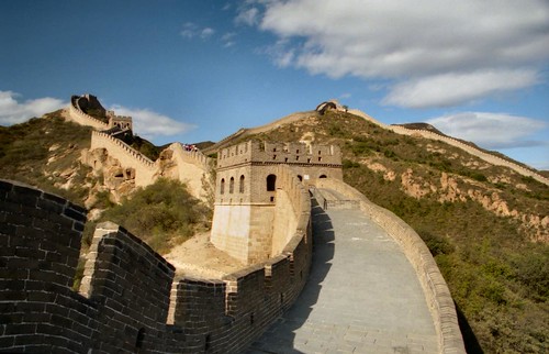
The Great Wall of China

The Great Wall of China With Beautiful Sky View
A Beautiful Shot of The Great Wall With a Gorgeous Sky
Photo by: topgold, Creative Commons

The Great Wall of China, a memorable landmark, is the most popular tourist attraction in China. The Wall has fascinated the minds of many in the world and it is part of the Seven Wonders of the World. The Great Wall is the ultimate tourist destination for sightseeing. People from all over the world visit China to see this exotic architecture because it is one of the most appealing attractions of China. It has its share of fans including those who spread speculations about it being seen from the moon.

Why, When, and Who Built The Great Wall?

Looking down at the Great Wall from the sky is truly amazing, the Wall resembles a Chinese dragon circling the mountains. There is a common term use by The Chinese call “Wan Li Chang Cheng” which defines as “Wall of 10,000 Li” (10,000 Li = 5,000 km). There were three main Chinese dynasties that contributed to the construction of the Great Wall: first, the Qin from 221-207 B.C., then the Han from 206 B.C – 220 A.D and the Ming from 1368-1644 A.D. Their common purpose was to stop the “barbaric” Huns in the North from invading the Chinese borders. Millions of people labored on the Great Wall and many died while working.

How Long is The Great Wall?

After the Qin emperor unified China, he connected the walls across the country into one, The Wall extended up to 10,000 Li (5000 km) and it helps keep out intruders from the north. What seems to be a Chinese zigzag dragon, the Great Wall of China spreads across deserts, rivers, mountains, grasslands and plateaus expanding nearly 6,700 kilometers. It has been built for over 2 millenniums and it stretches from the east side to the west side of China. Due to modern technologies and lack of usefulness, pieces of the structure are left in ruins and the Chinese leaders do not care to fix it. This marvelous segment of Chinese heritage swept through Shanhaiguan Pass, then to Liaoning, then Hebei, continuing onto Tianjin, expanding to Beijing, reaching Shanxi, and into Inner Mongolia, next to Ningxia, arriving at Gansu and finally ends in Jiayuguan Pass. The Great Wall length measures about 6,700 km long. Height wise, it is 4.5m to 9m. Depth wise, it is 4.5m to 8m. The entire structure was built by hand using stone, bricks, soil, sand, straw, wood, clay or whatever was available depending on the territory and time period.

The Great Wall Today

The existing Wall today was constructed by the Ming Dynasty over 600 years ago. During that time, the original wall was in ruins. Ming emperors order to rebuilt the wall over the course of 200 years. The reason the wall still stand today is because there was an invention during that time, mixing rice flour to create extremely tough bricks and mortar. Today, few parts of the Great Wall are in great condition because it was restored to attract tourists.

"The Great Wall of China" - 长城 by SmokingPermitted -
The Great Wall of China by exfordy.
The Great Wall of China by mooney47.
DSC00858 by Saad.Akhtar.
Great Wall of China at Badaling by jaaron.
IMG_1521 by beggs.
Snaking Chinese majesty by rarbol2004.

IMG_1593 by beggs.
IMG_1320 by beggs.
IMG_1626 by beggs.
IMG_0968 by beggs.
Don't litter by Augapfel.
IMG_1257 by beggs.
[TWS2008] Great Wall of China by scion_cho.
»»  Read More
 

© 2009World Heritage | by TNB